![http://UPSC%20coaching%20in%20India%20-%20Best%20UPSC%20coaching%20institute%20-%20UPSC%20Mentor%20coaching%20-%20UPSC%20preparation%20institute%20-%20IAS%20coaching%20center%20-%20UPSC%20online%20coaching%20-%20Best%20IAS%20coaching%20in%20India%20-%20UPSC%20classes%20for%20beginners%20-%20Civil%20services%20preparation%20-%20IAS%20preparation%20institute%20-%20UPSC%20mentorship%20program%20-%20UPSC%20exam%20guidance%20-%20IAS%20study%20material%20-%20UPSC%20Prelims%20coaching%20-%20UPSC%20Mains%20coaching%20-%20UPSC%20interview%20preparation%20-%20Best%20IAS%20online%20classes%20-%20UPSC%20coaching%20with%20personal%20mentorship%20-%20Affordable%20UPSC%20coaching%20-%20UPSC%20test%20series%20-%20UPSC%20coaching%20near%20me%20-%20Best%20IAS%20coaching%20near%20me%20-%20UPSC%20institute%20in%20[your%20city]%20-%20IAS%20coaching%20center%20in%20[your%20city]%20-%20The%20UPSC%20Mentor%20coaching%20-%20The%20UPSC%20Mentor%20IAS%20classes%20-%20The%20UPSC%20Mentor%20UPSC%20course%20-%20UPSC%20Mentor%20online%20program.](https://theupscmentor.in/wp-content/uploads/2024/11/THE-UPSC-2-e1762319162137.png)
 admin
admin 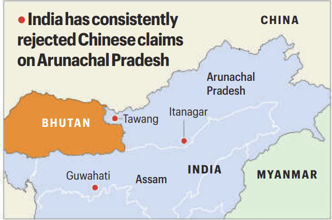
0.1 What the Line of Actual Control (LAC) actually is
0.1.1 The Line of Actual Control (LAC) is not a legally recognised international boundary. It merely reflects the areas where Indian and Chinese troops are physically present at a given time.
0.1.2 The LAC exists because India and China have never reached a mutually accepted boundary agreement after independence and the Chinese takeover of Tibet.
0.1.3 Since there is no jointly accepted map, both sides patrol according to their own perception of where the LAC lies. This means the LAC exists in practice, not on paper — making disagreement inevitable.
0.2 Difference between a boundary and the LAC
0.2.1 A boundary is the outcome of legal negotiation, diplomatic agreement, and formal ratification. Once fixed, it is not supposed to change with troop movement.
0.2.2 The LAC, by contrast, is only a temporary military arrangement meant to avoid clashes until a boundary is settled. It was never intended to define sovereignty.
0.2.3 When one side begins treating this temporary control line as a de facto boundary, it opens space for manipulation — because control can change without legal consequence.
0.3 What the McMahon Line is
0.3.1 The McMahon Line was drawn during the Simla Conference.
0.3.2 It demarcated the boundary between British India and Tibet in the Eastern Sector, corresponding to present-day Arunachal Pradesh.
0.3.3 The line followed natural mountain ridges and traditional administrative limits, reflecting established governance rather than arbitrary division.
0.4 Who participated in drawing the McMahon Line
0.4.1 Representatives of British India, Tibet, and China were present at the Simla Conference.
0.4.2 Tibet negotiated directly and independently, exercising effective control over its territory at that time.
0.4.3 China objected later to the agreement, primarily because it rejected Tibet’s status, not because the boundary itself was flawed.
0.5 Why China’s objection to the McMahon Line is disputed
0.5.1 In 1913–14, China did not exercise sovereignty over Tibet, and therefore lacked authority over the territory concerned.
0.5.2 China established control over Tibet only in 1950, decades after the line was drawn.
0.5.3 India argues that retrospectively invalidating a boundary based on later political changes has no legal standing.
0.6 Why the McMahon Line matters today
0.6.1 India treats the McMahon Line as a settled and final boundary in the Eastern Sector.
0.6.2 China began disputing it later, particularly around Tawang, citing historical and religious links.
0.6.3 This dispute keeps Arunachal Pradesh geopolitically sensitive despite long-standing Indian administration.
0.7 How the concept of the LAC was introduced
0.7.1 In 1959, Zhou Enlai formally introduced the term “Line of Actual Control”.
0.7.2 He proposed that both sides accept positions held by troops on the ground as the basis of separation.
0.7.3 India rejected this because it would legitimise advances made through force rather than agreement.
0.8 Impact of the 1962 war on the LAC
0.8.1 After the Sino-Indian War, Chinese forces withdrew in the Eastern Sector but retained positions elsewhere.
0.8.2 This made military occupation, not diplomacy, the basis of separation.
0.8.3 The LAC thus emerged as a post-war outcome, not a negotiated settlement.
0.9 Why China treats the LAC as flexible
0.9.1 China does not view the LAC as fixed because it has never agreed to a common map.
0.9.2 In the absence of a map, patrolling patterns become evidence of control.
0.9.3 When Chinese patrols visit an area more frequently, China later claims that area was always within its perceived LAC.
0.9.4 Infrastructure construction then reinforces this claim by creating permanence.
0.9.5 Since no boundary is crossed on paper, China can deny violations while changing ground reality.
0.10 Why India treats the LAC differently
0.10.1 India views the LAC strictly as a temporary stabilising mechanism.
0.10.2 It does not accept patrol presence as proof of sovereignty.
0.10.3 This fundamental difference in interpretation produces repeated standoffs.
0.11 What the watershed principle means
0.11.1 A watershed is a ridge dividing river systems.
0.11.2 India uses the highest watershed principle to interpret traditional Himalayan boundaries.
0.11.3 China sometimes claims areas south of the watershed, creating overlapping claims.
0.12 Sector-wise nature of the dispute
0.12.1 In the Eastern Sector, the dispute centres on interpretation of the McMahon Line.
0.12.2 In the Western Sector (Ladakh), China aligns the LAC with shifting claim lines.
0.12.3 In the Middle Sector, limited claims keep ambiguity alive.
0.13 Why India accepted the LAC in 1993
0.13.1 India accepted the LAC under the Border Peace and Tranquillity Agreement.
0.13.2 This acceptance was pragmatic, not legal.
0.13.3 The goal was to maintain peace pending final settlement.
0.14 Why confidence-building measures failed
0.14.1 Agreements in 1993 and 1996 regulated troop behaviour.
0.14.2 They assumed mutual respect for existing positions.
0.14.3 Continued transgressions revealed exploitation of ambiguity.
0.15 What LAC clarification meant
0.15.1 Clarification meant exchanging maps of perceived LAC alignments.
0.15.2 Progress occurred only in the Middle Sector.
0.15.3 China refused map exchange in the Western Sector to preserve flexibility.
0.16 What grey-zone operations mean
0.16.1 Grey-zone operations lie between peace and war.
0.16.2 They involve gradual actions that change facts on the ground without open conflict.
0.16.3 Ambiguity makes such actions possible.
0.17 Why Arunachal Pradesh is targeted
0.17.1 China refers to Arunachal Pradesh as “South Tibet”.
0.17.2 Renaming places and administrative signalling reinforce claims.
0.17.3 This applies sustained political and psychological pressure.
0.18 Core logic in simple words
0.18.1 Clarity limits expansion; ambiguity enables pressure.
0.18.2 China therefore avoids a settled boundary.
0.18.3 The LAC is used as a strategic instrument, not a peace line.
![UPSC coaching in India - Best UPSC coaching institute - UPSC Mentor coaching - UPSC preparation institute - IAS coaching center - UPSC online coaching - Best IAS coaching in India - UPSC classes for beginners - Civil services preparation - IAS preparation institute - UPSC mentorship program - UPSC exam guidance - IAS study material - UPSC Prelims coaching - UPSC Mains coaching - UPSC interview preparation - Best IAS online classes - UPSC coaching with personal mentorship - Affordable UPSC coaching - UPSC test series - UPSC coaching near me - Best IAS coaching near me - UPSC institute in [your city] - IAS coaching center in [your city] - The UPSC Mentor coaching - The UPSC Mentor IAS classes - The UPSC Mentor UPSC course - UPSC Mentor online program.](https://theupscmentor.in/wp-content/uploads/2025/11/cropped-THE-UPSC-1.png)